Code: TPLIPEZ Duration: 14 days
The Bolivian highland or “Altiplano” - as it is called in Spanish -, is located in the central Andes. Due to its unique geography, the southern Altiplano is one of the most extraordinary features in our planet, hosting more volcanoes per square kilometer than anywhere else above sea level. The volcanic activity, and later erosion action, has created unique places like the Uyuni salt flats; a world's top destination; certainly one of the wonders of nature you must not miss.
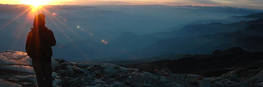
Several ancient cultures have always considered volcanoes holy sites, and the house of the “Achachilas”: the ancient, immortal guardians. In those summits they felt closer to their gods and offered sacrifices, some of them human.
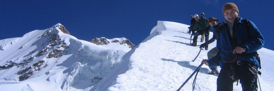
Our expedition starts at Lake Titicaca heading then to the southern highlands visiting on the way Uyuni salt flats. Along of the way we will take several short acclimatization hikes to be ready to trek to the top of the three chosen volcanoes: Tapaquilcha, Llicancabur and Acotango; all of them with amazing views than could be 300km radio in a clear day.
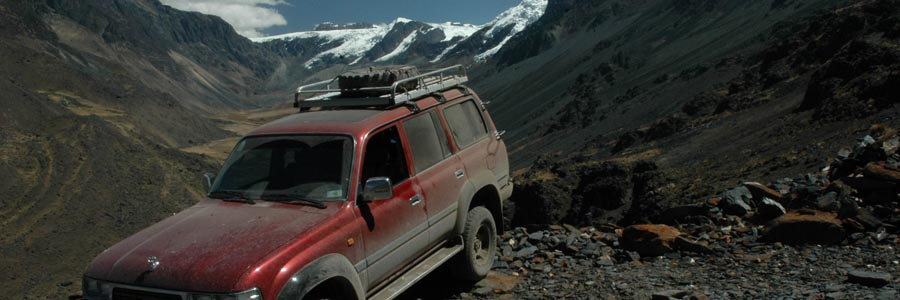
Although little known Tapaquilcha is a great first climb, thanks to old minis roads we can drive up to 5000m before hiking to the summit. Llicancabur is a little more demanding since involve a little more than 1200m of ascent. Depending of the season Acotango may have a snow field but no technical climb is required.
Short Itinerary
Day 1. Arrival to La Paz. Transfer IN. Hotel.
Day 2. Hike on Peñas Range. Transport to Copacabana. Hotel.
Day 3. Trek to Chincana. Transport to La Paz. Hotel.
Day 4. Transport to Colchani. Hotel.
Day 5. Transport to Mallku. Camp.
Day 6. Climb of Tapaquilcha. Camp.
Day 7. Transport to Laguna Verde. Basic hostel.
Day 8. Climb of Llicancahur. Basic hostel.
Day 9. Transport to Mallku. Camp.
Day 10. Transport to Isla Pescado. Camp
Day 11. Transport to Sajama. Camp
Day 12. Climb of Acotango. Camp.
Day 13. Transport to La Paz. Hotel.
Day 14. Departure. Transfer to Airport.
Highlights
- Acclimatization sightseeing La Paz & Lake Titicaca.
- Hike to the scenic view point of Peñas range.
- 4WD journey to the Uyuni salt flats, and Colorada & Verde lagoons.
- Ascents to three sacred volcanoes in the Lipez and Sajama National Park, including: Tapaquilcha 5,758m, Llicancahur 5,940m and Acotango 6,056m.
- Visit to Sajama National Park.
Services Included
- All transfers IN/OUT to airports.
- Meals mentioned in the itinerary.
- Full land transportation during the trip.
- Hotel accommodation as mentioned in the itinerary.
- Common camping equipment: 3 season tents, dinning and kitchen tents & tableware.
- Bilingual guide during the trip.
- Luggage transportation with porters and/or animals (15 kg/33 lb per person max weight).
- Cook when camping.
- National Park entrance fees.
Services Not Included
- International & local flight tickets & fees.
- Meals while in La Paz.
- Personal camping equipment: sleeping bag, mattress, headlamps, and clothing.
- Personal climbing equipment: plastic boots, crampons
- Insurance of any kind.
- Any expense due to a rescue operation (rescuers fee, transportation, or medical cost).
Day to day details
Arriving at the airport in La Paz your breath will be taken away. Not just because of the altitude; the airport is the highest international airport in the world; but also because of the views over the mountains. The crisp clear sky of the highlands give the impression you could touch them. In a normal winter day it is possible to see over a distance of 200Km (120mi). The cold and dry air feels good after so many hours of treated pressurized cabin air.
The drive to the city of La Paz is not less impressive. We will stop at “La Ceja” (literally the eyebrow in Spanish; but also meaning the edge) and have a view on the amazing city with buildings and houses hanging from the steep slopes and filling the whole valley that is surrounded by huge glaciated mountains.
Then we will descend 500m (1640ft) down to our hotel in downtown. Do not get stressed much about the altitude; our program has been designed to get you gradually acclimatized. At the beginning we strongly suggest you to take it very easy, drink plenty of water and eat lightly (get into out Acclimatization page for more information).
You will have the rest of the day free. At early evening we will have a briefing meeting.
Overnight: Hotel Nayra
El Alto: 4,100m (13,450ft)
La Paz: 3,650m (11,972ft)
Driving: 30Min (11km)
None
After breakfast we will take our transport and head north towards Lake Titicaca. Half of the way we will do our first hike in this small rocky range facing Cordillera Real. After the hike we will board our vehicle to get to the shores of the lake where we will stay in one of the best hotels in the area.
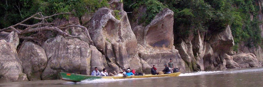
Traveling through this land it is easy to understand how important the shores of Lake Titicaca have been in the development of Andean cultures. Surrounded by desert like hills and snowcapped mountains, the lake offered, and still offers, rich lands and a mild climate. On the way to Copacabana, we will be culturally transferred to the past as we go by Aymara villages where Indians have been keeping their lifestyle for centuries.
Overnight: Hotel Rosario del lago
Trailhead 4,011m (13,156ft)
Peñas 4,333m (14,212ft)
Lake Titicaca 3,810m (12,497ft)
Driving: 4-5Hrs (185km)
Walking: 3-4Hrs (4km)
B,L,D
An early start to make a short but pleasant drive along of the shores of Copacabana peninsula towards the village of Yampupata, there we will board the motor boat that will take us to the Island of the Sun. Today we will trek the whole length of the island admiring the Inca terraces, many of which are still used, passing through villages and walking along sandy beaches. Our objective is to reach the north-west end of the island where we can visit a sacred rock, which was worshipped as the birthplace of the first Incas: MancoKapac and Mama Okllo, son and daughter of Viracocha. We will also have time to visit the ruins of Chincana (the labyrinth). After lunch we will take our motor boat back to mainland and then our vehicle towards La Paz city.
Overnight: Hotel Nayra
Island of the sun 4,065m (13,333ft)
Chincana 3,830m (12,529ft)
La Paz: 3,650m (11,972ft)
Walking: 3-4Hrs (11km)
Motor boat: 2-3Hrs (13km)
Driving: 4-5Hrs (176km)
B,L
Along of the way we will traverse part of the northern highlands ( “Altiplano”) passing by the city of Oruro that 15 years ago thrived on the area’s tin mines, nowadays relies on its role as a center of commerce (read smuggling) between Bolivia and Chile. Continuing our journey to the south, we enter the seemingly never ending plains. It will be late afternoon when we get to Colchani Town where we will stay in a unique hotel made mostly with salt blocks.
Overnight: Hotel Luna Salada
Colchani: 3,677m (12,061ft)
Driving: 8-10Hrs (558km)
B,L
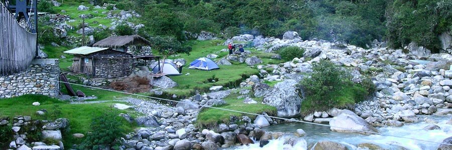
We will continue south crossing never-ending plains. On the way we will pass by Uyuni town where we will pay a visit to the train cemetery. The road passes by one of the world’s biggest silver mine: San Cristobal. It is said that this mine is several times richer that the one in Potosi and among the richest in the planet. After midday we will be at the Lava canons and set the campsite into one of the most spectacular canyons in the area near to a warm water spring. Later we will hike and explore this bizarre landscape.
Overnight: Camping
Mallku canyons: 3,876m (12,713ft)
Driving: 4-5Hrs (200km)
Walking: 2-3Hrs(4km)
B,L,D
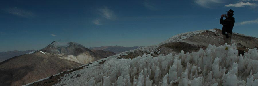
The provinces of Lipez were baptized by the National Geographic as “The Andean Tibet” and one of the most spectacular places in the Andes. The color-washed volcanoes, deserts, lagoons, bizarre formations of petrified lava, Geysers, fumaroles and the wildlife are complementary to the landscape’s immensity and the intense blue sky. Early in the morning we will leave our campsite with the car that will approach as high as possible on an old sulfur-mining road. From this point we will have an easy yet strenuous walk to the last col, from where we will ascend on rough sandy terrain towards the main summit. The crest is what remains of a volcanic explosion in the long-distant past. Later we drop back down over the slopes to the car that will drive us back to the campsite.
Overnight: Camping
Trailhead: 5,137m (16,849ft)
Tapaquilcha: 5758m (18,886 ft)
Mallku canyons: 3,876m (12,713ft)
Driving: 4-6Hrs (132km)
Walking: 5-6Hrs(5.5km)
B,L,D
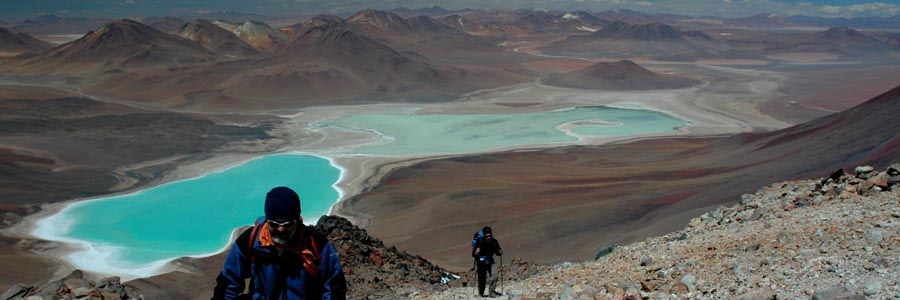
We continue our drive south, towards “Eduardo Avaroa” National Reserve of Andean Fauna. On the way, we will pass by Colorada Lagoon, the Geysers of “Sol de Mañana” (morning’s sun), Chalviri lagoon and the rocky monuments of “Dali Desert” before arriving to Laguna Verde (green Lagoon). There we will stay in a basic hostel for the night.
Overnight: Basic hostel
Road pass: 4,900m (16,072ft)
Laguna Verde: 4,366m (14,320ft)
Driving: 6-7Hrs (228km)
B,L,D
After a short drive The climb of Llicancahur is not technical but very demanding. The crater rim stands more than 1.200m above our campsite and takes a lot of effort to get to. There is a small lake inside the crater, despite the cold and altitude this lake is rarely frozen, reminding us that we are still on an active volcano. The night will be spent at the same basic hostel.
Overnight: Basic hostel
Trailhead: 4549m (14,920ft)
Llicancabur: 5,940m (19,483ft)
Laguna Verde: 4,366m (14,320ft
Driving: 1Hr (23km)
Walking: 7-8Hrs (8.5km)
B,L,D
Now we start our way back north. After again more lakes and salt flats we will get to the same canyons where we camped before attempting Tapaquilcha volcano.
Overnight: Camping
Road pass: 4,900m (16,072ft)
Mallku canyons: 3,876m (12,713ft)
Driving: 6-7Hrs (228km)
B,L,D
After traversing the low passes in between the volcanoes, we will continue over vast deserted expanses heading north. Along of the way, we’ll enjoy the wild landscape that surrounds the salt lake with its colored volcanoes. Once at the Uyuni Salt Flats, we will navigate over the rock hard salt. In the midst of the Salar's blinding sea of white (take sunglasses!) there exist several solid rock and earth islands each having distinct flora and fauna. We reach “Fishback” island where we will set up camp. During the afternoon we can walk up to the island’s Summit or around the island in order to observe the sunset.
Overnight: Camping
Pescado island: 3,650m (11,716ft)
Top of the island: 3,826m (12,549ft)
Driving: 7-8Hrs (290km)
B,L,D
After traversing Uyuni salt flats we exit this salt expanse by the west though Llica town, then head towards the north crossing a desert that amazes us with its features. Coipasa is a smaller salt lake than Uyuni but still spectacular, it has a huge volcano island in its center. More driving through sandy deserts will take us to the boundaries of Sajama national Park, location of the biggest volcanoes in Bolivia. At Sajama, we will set our campsite near to the hot springs.
Overnight: Camping
Sajama campsite: 4,260m (13,973ft)
Driving: 9-10Hrs (450km)
B,L,D
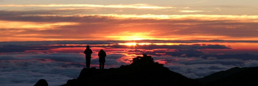
An early start to drive on a paved road towards the border with Chile and then take the dirt road that leads to an old sulfur mine. Once at the trailhead we will leave the car and start hiking towards the crater rim of this volcano. Although not technically difficult this is a long route, walking sometimes over steep and lose terrain we gain altitude. Often the wind can be an added challenge during the ascent. From the top of the ridge we can admire both national parks at each country side: Sajama and Lauca. The summit has normally a small ice or snow field, and sometimes late in the season there can be “Penitentes”. After taking lunch, if the wind allows us to stay up there, we will return to the trailhead where the vehicles will be waiting to take us back to our campsite in Sajama.
Overnight: Camping
Acotango road-head: 5056m (16,584ft)
Acotango: 6,056m (19,863ft)
Sajama campsite: 4,260m (13,973ft)
Driving: 3-4Hrs (120km)
Walking: 8-10Hrs (7km)
B,L,D
No more walking today. Since we have plenty of time, we will pay a visit to Sajama National Park. Our vehicle will take us first to Sajama village where after registering ourselves at the National Park rangers hut, we will have lunch in the highest ‘forest’ of the planet. The local species of trees are called keñuas (PolilepsisTarapacana).and then to the hot springs where besides having a well-deserved relaxing hot bath we can have lunch, and later head back to La Paz.
Overnight: Hotel Nayra
El Alto: 4,100m (13,450ft)
La Paz: 3,650m (11,972ft)
Driving: 5-6Hrs (284km)
B,L
Transfer to airport.
Overnight: None
El Alto 4,100m (13,450ft)
Driving:30Min (11km)
None